Trump says climate predictions were ‘wrong’: How do climate models work, how accurate are they?
Trump says climate predictions were ‘wrong’: How do climate models work, how accurate are they?
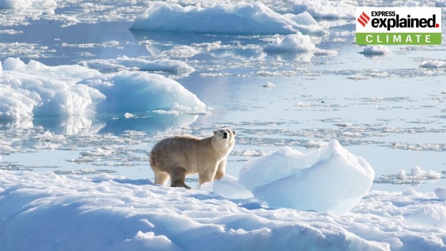 A southeast Greenland polar bear on glacier, or freshwater, ice. (Photo: Reuters)
US President Donald Trump, in his speech at the United Nations General Assembly on September 23, said that climate change was the greatest “con job” ever.
“All of these predictions made by the United Nations and many others, often for bad reasons, were wrong. They were made by stupid people that have cost their countries fortunes and given those same countries no chance for success,” he said.
The predictions that Trump alluded to in his speech are usually made using climate models. These computer programs are at the heart of climate research: they help scientists understand how the climate changed in the past, how it is changing now, and how it might change in the future.
But how do climate models work? What are the different types of climate models? How accurate are they?
What are climate models?
A climate model is a computer simulation that uses mathematical formulae and algorithms to replicate how the Earth’s climate system — including the atmosphere, ocean, land and ice — works.
Vidya S, senior associate at the Centre of Science, Technology and Policy (CSTEP), a Bengaluru-based think tank, told The Indian Express over email, “These models are built on the principles of physics, chemistry, and biology, and are designed to simulate or mimic the interactions between the atmosphere, oceans, land surface, and ice.”
Climate models can forecast how variables such as temperature and humidity will change over time under different scenarios, like increased greenhouse gas emissions or changes in land use. Simply put, they allow scientists to test hypotheses and draw conclusions on past and future climate systems.
This also helps them to determine if abnormal weather events like extreme heavy rainfall are a result of changes in climate or just part of routine climate variation.
Note that climate models are different from weather models. While weather models make predictions over specific areas and short time spans, climate models are broader and analyse long-term patterns.
How do climate models work?
A modern climate model first divides the Earth into a three-dimensional grid, with cells extending across the planet’s surface, up into the atmosphere, and down into the ocean. Each cell is represented by mathematical equations that describe the materials — land, air, and ice — within it, and the way energy moves through it.
Scientists then feed input data from observations, for example, of greenhouse gases or ocean conditions, and have the model solve equations to determine how the weather will change within each cell, what impacts those changes will have on adjacent cells, and what changes those adjacent cells will have on others. This allows scientists to gain an understanding of the effects on a particular region or the entire planet.
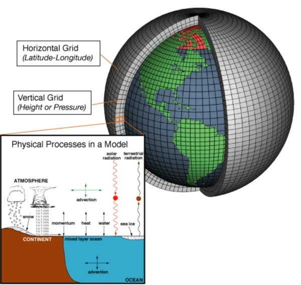 A modern climate model divides the Earth into a three-dimensional grid, with cells extending across the planet’s surface, up into the atmosphere, and down into the ocean. Each cell is represented by mathematical equations. Credit: NOAA
The output from the model can include “projected changes in temperature and precipitation patterns, sea-level rise, ocean circulation, frequency and intensity of extreme weather events (such as heatwaves, droughts, and storms), and shifts in snow and ice cover,” Vidya said.
How have climate models evolved over the years?
* The earliest form of climate models, known as the Energy Balance Models (EBMs), emerged in the 1960s. These only determine surface temperature by considering the balance between the energy entering the Earth’s atmosphere from the Sun, and the heat released back out to space.
* Then came Radiative Convective Models (RCMs), which are more complex and simulate the transfer of energy through the height of the atmosphere. They estimate both surface temperature and the temperature variation with elevation.
* Subsequently, General Circulation Models (GCMs), also called Global Climate Models, emerged. They are the most sophisticated and precise models for understanding climate systems and predicting climate change. GCMs simulate Earth’s atmosphere, oceans, land, and ice to represent large-scale climate processes over time, including the movement of energy and matter.
* There are also Regional Climate Models (RCMs) that do a similar job as GCMs, but offer more precise local forecasts and concentrate on smaller regions, such as a country or a continent.
Also in Explained | Is Earth becoming warmer?
How accurate are climate models?
Researchers say that modern climate models are fairly accurate when it comes to capturing large-scale patterns and long-term changes, particularly at the global level.
“Over the past few decades, they have been successful in forecasting several important phenomena, like sea-level rise and polar ice loss. When averaged over wide regions and time periods, models also do a good job of simulating general patterns of temperature, precipitation, and ocean circulation,” said Vidya.
One way scientists check the accuracy of models is by using past events. If the model accurately predicts past events that scientists know took place, then it should also be able to accurately predict future events.
That said, current climate models are not perfect. This is because of imperfect, incomplete, or unavailable data on complex, dynamic processes such as the nature of clouds, the climatic effects of sudden geophysical events such as a volcanic eruption, or natural phenomena such as El Niño events.
Climate models also overlook regional specifics such as intense rain in rural areas, flooding in urban areas, or heat in towns, as they view the Earth in broad sections, typically ranging from 100 to 250 kilometres (the size of each cell of the three-dimensional grid), according to Vidya.
“Moreover, these models frequently oversimplify the interactions between land and air, such as how farms, trees, and soil moisture impact rain and temperature. Climate models might, therefore, overestimate or underestimate extreme occurrences like heat waves or torrential rains,” she said.
The most glaring shortcoming of these models is that they tend to be less accurate in the Global South. This could be because of inadequate ground data, and more complex and poorly represented regional climate patterns, such as the Indian monsoon.
“Most climate models were initially created in North America and Europe… Because the Global North has more accurate and detailed observational records, climate models are frequently calibrated and validated using data from this region,” said Vidya.
These flaws, however, do not mean that climate models are useless. Since they are based on well-founded physical principles of Earth system processes, climate models are still one of the best ways to understand general climate patterns and make policy decisions to mitigate the adverse effects of climate change.
As such, almost all climate models and climate scientists agree on one fundamental fact: that climate change is real, and the rise of the global mean surface temperatures is due to the continuing emission of heat-trapping greenhouse gases.
트럼프는 기후 예측이 '잘못'이라고 말합니다. 기후 모델은 어떻게 작동 하는가, 얼마나 정확한가?
빙하 또는 담수, 얼음에 대한 남동쪽 그린란드 북극곰. (사진 : 로이터)
도널드 트럼프 미국 대통령은 9 월 23 일 유엔 총회 연설에서 기후 변화가 가장 큰“사기”라고 말했다.
"유엔과 다른 많은 사람들이 이루어진 모든 예측은 종종 나쁜 이유로 잘못되었다. 그들은 나라의 운이 좋았으며 같은 나라들에게 성공할 기회가없는 멍청한 사람들에 의해 만들어졌다"고 그는 말했다.
트럼프가 그의 연설에서 언급 한 예측은 일반적으로 기후 모델을 사용하여 만들어집니다. 이러한 컴퓨터 프로그램은 기후 연구의 핵심입니다. 과학자들은 과거의 기후가 어떻게 변했는지, 현재 변화가 어떻게 변하고 있는지, 미래의 변화가 어떻게 변할 수 있는지 이해하도록 돕습니다.
그러나 기후 모델은 어떻게 작동합니까? 기후 모델의 다른 유형은 무엇입니까? 그들은 얼마나 정확합니까?
기후 모델이란 무엇입니까?
기후 모델은 수학적 공식과 알고리즘을 사용하여 대기, 바다, 육지 및 얼음을 포함한 지구의 기후 시스템이 어떻게 작동 하는지를 복제하는 컴퓨터 시뮬레이션입니다.
Bengaluru 기반의 싱크 탱크 인 과학, 기술 및 정책 센터 (CSTEP)의 수석 부교수 인 Vidya S는 Indian Express에 이메일을 통해 다음과 같이 말했습니다.“이 모델은 물리, 화학 및 생물학의 원리에 기반을두고 있으며 대기, 해양, 지표면 및 얼음 사이의 상호 작용을 시뮬레이션하거나 모방하도록 설계되었습니다.
기후 모델은 온실 가스 배출 증가 또는 토지 사용 변화와 같은 다양한 시나리오에서 시간이 지남에 따라 온도 및 습도와 같은 변수가 어떻게 변하는 지 예측할 수 있습니다. 간단히 말해서, 과학자들은 가설을 테스트하고 과거와 미래 기후 시스템에 대한 결론을 도출 할 수 있습니다.
이것은 또한 극도의 폭우와 같은 비정상적인 날씨 사건이 기후의 변화 또는 일상적인 기후 변화의 일부로 인해 발생하는지 확인하는 데 도움이됩니다.
기후 모델은 날씨 모델과 다릅니다. 날씨 모델은 특정 영역과 짧은 시간에 대한 예측을하지만 기후 모델은 더 넓고 장기 패턴을 분석합니다.
기후 모델은 어떻게 작동합니까?
현대 기후 모델은 먼저 지구를 3 차원 그리드로 나눕니다. 각 셀은 재료 (토지, 공기 및 얼음) 내에서 에너지가 움직이는 방식을 설명하는 수학적 방정식으로 표시됩니다.
그런 다음 과학자들은 예를 들어 온실 가스 또는 해양 조건에 대한 관측치로부터 입력 데이터를 공급하고 모델이 각 세포 내에서 날씨가 어떻게 변하는지를 결정하기 위해 방정식을 해결하고, 이러한 변화가 인접한 세포에 미치는 영향 및 인접한 세포의 변화에 어떤 영향을 미치는지를 결정합니다. 이를 통해 과학자들은 특정 지역이나 지구 전체에 미치는 영향을 이해할 수 있습니다. 현대 기후 모델은 지구를 3 차원 그리드로 나누고, 세포는 지구 표면을 가로 질러 대기로, 바다로 내려갑니다. 각 셀은 수학적 방정식으로 표시됩니다. 신용 : NOAA
Vidya는이 모델의 출력에는 온도 및 강수량 패턴의 예상 변화, 해수면 상승, 해양 순환, 빈파, 가뭄 및 폭풍 등의 극한 날씨 사건 (예 : 눈과 얼음 덮개의 교대)이 포함될 수 있습니다.
기후 모델은 수년에 걸쳐 어떻게 진화 했습니까?
* 에너지 균형 모델 (EBM)으로 알려진 기후 모델의 초기 형태는 1960 년대에 나타났습니다. 이것은 태양으로부터 지구 대기로 유입되는 에너지 사이의 균형과 열이 다시 우주로 나오는 열의 균형을 고려함으로써 표면 온도를 결정합니다.
* 그런 다음 복사 대류 모델 (RCM)이 왔는데, 이는 더 복잡하고 대기 높이를 통해 에너지 전달을 시뮬레이션합니다. 그들은 표면 온도와 고도에 따른 온도 변화를 모두 추정합니다.
* 그 후 글로벌 기후 모델이라고도 불리는 일반 순환 모델 (GCMS)이 등장했습니다. 기후 시스템을 이해하고 기후 변화를 예측하기위한 가장 정교하고 정확한 모델입니다. GCM은 에너지와 물질의 움직임을 포함하여 시간이 지남에 따라 대규모 기후 과정을 나타 내기 위해 지구의 대기, 바다, 육지 및 얼음을 시뮬레이션합니다.
* GCM과 비슷한 작업을 수행하지만보다 정확한 지역 예측을 제공하고 국가 나 대륙과 같은 소규모 지역에 집중하는 지역 기후 모델 (RCM)도 있습니다.
또한 설명 | 지구가 따뜻해지고 있습니까?
기후 모델은 얼마나 정확합니까?
연구원들은 현대 기후 모델이 대규모 패턴과 장기적인 변화, 특히 전 세계 수준에서 상당히 정확하다고 말합니다.
Vidya는“지난 수십 년 동안 해수면 상승 및 극성 얼음 손실과 같은 몇 가지 중요한 현상을 예측하는 데 성공 해 왔습니다. 넓은 지역과 기간에 걸쳐 평균화 될 때 모델은 온도, 침전 및 해양 순환의 일반적인 패턴을 시뮬레이션하는 데 도움이됩니다.
과학자들이 모델의 정확성을 확인하는 한 가지 방법은 과거 이벤트를 사용하는 것입니다. 모델이 과학자들이 알고있는 과거 사건을 정확하게 예측한다면 미래의 사건을 정확하게 예측할 수 있어야합니다.
즉, 현재 기후 모델은 완벽하지 않습니다. 이는 구름의 본질, 화산 분화와 같은 갑작스런 지구 물리학 적 사건의 기후 효과 또는 엘 니뇨 사건과 같은 자연 현상과 같은 복잡한 역동적 인 프로세스에 대한 불완전한, 불완전하거나, 이용할 수없는 데이터 때문입니다.
기후 모델은 또한 시골 지역의 강렬한 비, 도시 지역의 홍수 또는 도시의 열과 같은 지역별 특성을 간과합니다. 비다에 따르면 지구를 넓은 구역으로 보며 100 ~ 250 킬로미터 (3 차원 그리드의 각 세포의 크기)는 지구를 보았습니다.
그녀는“이러한 모델은 농장, 나무 및 토양 수분 비와 온도와 같은 토지와 공기 사이의 상호 작용을 자주 지나치게 단순화합니다. 따라서 기후 모델은 열파 나 폭우와 같은 극심한 발생을 과대 평가하거나 과소 평가할 수 있습니다.
이 모델의 가장 눈부신 단점은 전 세계 남부에서 덜 정확한 경향이 있다는 것입니다. 이는 부적절한 지상 데이터와 인도 몬순과 같은 더 복잡하고 제대로 표현되지 않았기 때문일 수 있습니다.
Vidya는“대부분의 기후 모델은 처음에는 북미와 유럽에서 만들어졌습니다. 전 세계 북부는보다 정확하고 상세한 관찰 기록을 가지고 있기 때문에 기후 모델은이 지역의 데이터를 사용하여 자주 교정 및 검증됩니다.
그러나 이러한 결함이 기후 모델이 쓸모가 없다는 것을 의미하지는 않습니다. 그것들은 지구 시스템 프로세스의 잘 알려진 물리적 원리를 기반으로하기 때문에 기후 모델은 여전히 일반적인 기후 패턴을 이해하고 기후 변화의 부작용을 완화하기위한 정책 결정을 내리는 가장 좋은 방법 중 하나입니다.
따라서 거의 모든 기후 모델과 기후 과학자들은 기후 변화가 실제적이며 전 세계 평균 표면 온도의 상승은 열 포기 온실 가스의 지속적인 방출 때문이라는 하나의 근본적인 사실에 동의합니다.
대화 참여하기